

U.K., Ireland & Holland Navionics+ Chat
Featuring vibrant colours and a streamlined interface, navigate and plot your course with the Garmin Navionics+ U.K., Ireland and Holland Chart.

Featuring vibrant colours, a streamlined interface, and combined coastal/inland content with a popular Navionics® style colour palette, Garmin Navionics+ cartography makes plotting your course an easy job.
- All-In-One Map Solution for Garmin Chartplotters - Access detail-rich mapping of coastal features, lakes, rivers, and more. Integrated Garmin and Navionics content offers coverage for boaters worldwide.
- Daily Chart Updates - Charts are constantly being enhanced with new and amended content. The one-year included subscription gives users access to daily chart updates via the ActiveCaptain smart device app.
- Auto Guidance+ Technology - Combining the best of Garmin and Navionics automatic routing features, built-in Auto Guidance+ technology* gives users a suggested dock-to-dock path to follow through channels, inlets, marina entrances, and more.
- Depth Range Shading - High-resolution depth range shading allows users to select up to 10 colour-shaded options and view their designated target depths.
- Up to 0.5 Metre Contours - For improved fishing and navigation, up to 0.5 metre contours provide a clear depiction of bottom structure for improved fishing charts and enhanced detail in swamps, canals, harbours, marinas, and more.
- Shallow Water Shading - Giving a clear picture of shallow waters to avoid, this feature allows for shading at a user-defined depth.
- ActiveCaptain Community - Provides useful points of interest, such as marinas, anchorages, hazards, businesses, and more. Users can get recommendations from boaters with firsthand experience of the local environment.
- Seabed Areas - This feature helps users identify the type of seabed. This is helpful when deciding where to drop anchor and where to fish.
* Auto Guidance+ is for planning purposes only and does not replace safe navigation operations.
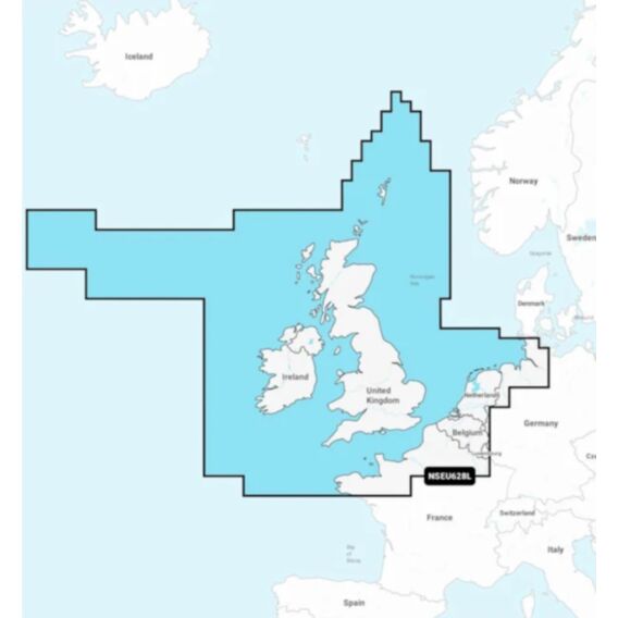
Coverage - This chartplotter provides detailed coverage of the UK, Ireland, and the North Sea and English Channel coasts. Coverage includes the Shetland Islands, Orkney Islands, Isle of Man, Isle of Wight, Isles of Scilly, Channel Islands, Thames River, Lake IJssel, and the Wadden Sea. Ports include London, Liverpool, Southampton, Edinburgh, and Belfast (UK); Dublin and Cork (Ireland); Brest, Le Havre, Calais, and Dunkirk (France); Antwerp (Belgium); Amsterdam and Rotterdam (The Netherlands); and Bremerhaven and Hamburg (Germany).
